Census 2020 shows metro areas have fueled Indiana's growth

The state’s five fastest-growing counties all bordered Marion County.
Indiana’s population growth over the past decade was largely driven by gains in a handful of metropolitan areas, according to the latest results from the 2020 Census.
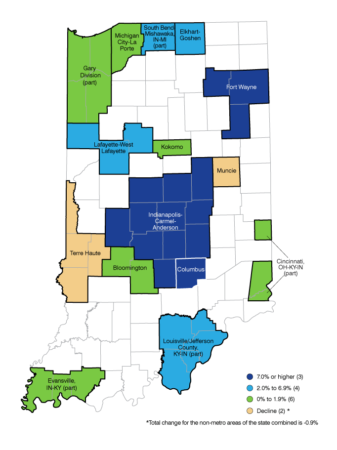
The 11-county Indianapolis-Carmel-Anderson metro area led the way by adding 223,163 residents between 2010 and 2020, an 11.8% increase. The Indy metro’s numeric growth accounted for 74% of the state’s net population gain.
With a population now at more than 2.1 million people, this central Indiana region’s share of the state’s total population increased from 29.1% in 2010 to 31.1% in 2020.
Other fast-growing metro areas in the state include Fort Wayne (7.6% growth), Columbus (7.1%), Lafayette (6.7%) and the Indiana portion of the Louisville metro (6.2%). The only Indiana metro areas to lose population over the decade were Muncie (-4.9% decline) and Terre Haute (-2.1%), as shown in Figure 1.
Figure 1: Population change in Indiana metros, 2010 to 2020

Source: IBRC, using U.S. Census Bureau data
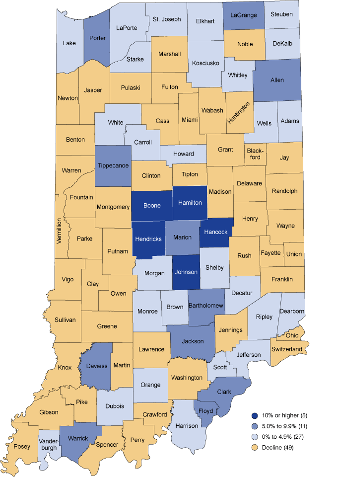
While many Indiana metro areas continue to grow, large swaths of the state—including most mid-sized and rural communities—saw populations decline between 2010 and 2020. All told, 49 of Indiana’s 92 counties lost population over this period (see Figure 2). This represents the largest number of Indiana counties to show a decline between censuses since the 1980s. Indiana is not alone in this trend since more than half of all U.S. counties lost population between 2010 and 2020.1
Figure 2: Population change in Indiana counties, 2010 to 2020

Source: IBRC, using U.S. Census Bureau data
The 44 Indiana counties that are part of a metropolitan statistical area combined to grow by 6.3% over the past decade. Meanwhile, the state’s 48 non-metro counties as a group declined by -0.9% over the same period.
For Indiana as a whole, the state added 301,726 residents since 2010—a 4.7% increase—and was home to nearly 6.8 million residents as of April 1, 2020.
Indiana’s leaders in population change
The state’s five fastest-growing counties all bordered Marion County. For the fifth consecutive decade, Hamilton County set the pace with a 26.5% increase between 2010 and 2020, followed by Boone (25.0%), Hendricks (20.2%), Johnson (15.8%) and Hancock (14.1%) counties.
Outside of Central Indiana, Clark County had the quickest rate of change at 9.9%, followed by Jackson (9.6%), LaGrange (8.9%) and Allen (8.5%) counties. Marion County posted the state’s largest numeric gain in population by adding 73,810 residents over the decade—an 8.2% increase.
At the other end of the spectrum, five rural counties—Switzerland (-8.3%), Greene (-7.1%) Parke (-6.8%), Pulaski (-6.6%) and Randolph (-6.4%) counties—had the state’s sharpest declines. Some relatively large Indiana counties that had significant population losses include Grant (-4.8%) and Wayne (-3.4%) counties.
Indiana’s largest counties
Each of Indiana’s 10-largest counties added population over the decade (see Table 1). Marion County is still the state’s most-populous county with 977,203 residents in 2020. With a 0.5% increase over the decade, Lake County grew to 498,700 residents. With the addition of 30,081 residents, Allen County reached a total population of 385,410 and maintained its position as the state’s third-largest county. Hamilton County grew by nearly 73,000 residents and ended the decade with a population of 347,467, however, and continues to close the gap on the third spot.
Neighboring St. Joseph (total population of 272,912) and Elkhart (207,047) counties are the only other Indiana counties with populations above the 200,000 mark in 2020. Tippecanoe (186,251), Vanderburgh (180,136), Hendricks (174,788) and Porter (173,215) counties round out the 10-largest counties in the state.
Table 1: Population change in Indiana’s largest counties
| County | 2020 population | Change since 2010 | Percent change since 2010 |
|---|---|---|---|
| Marion | 977,203 | 73,810 | 8.2% |
| Lake | 498,700 | 2,695 | 0.5% |
| Allen | 385,410 | 30,081 | 8.5% |
| Hamilton | 347,467 | 72,898 | 26.5% |
| St. Joseph | 272,912 | 5,981 | 2.2% |
| Elkhart | 207,047 | 9,488 | 4.8% |
| Tippecanoe | 186,251 | 13,471 | 7.8% |
| Vanderburgh | 180,136 | 433 | 0.2% |
| Hendricks | 174,788 | 29,340 | 20.2% |
| Porter | 173,215 | 8,872 | 5.4% |
Source: IBRC, using U.S. Census Bureau data
Learn more
Access more data for various levels of geography via STATS Indiana’s Census topic page.
Notes
- Paul Mackun, Joshua Comenetz, and Lindsay Spell, “More than half of U.S. counties were smaller in 2020 than in 2010,” U.S. Census Bureau: America Counts: Stories Behind the Numbers, August 12, 2021, www.census.gov/library/stories/2021/08/more-than-half-of-united-states-counties-were-smaller-in-2020-than-in-2010.html.
